Zones de protection des captages au Royaume-Uni
Concerning areas of protection of groundwater abstractions in United Kingdom, two reports enable to better understand the different zoning in this country, they are available here: https://www.gov.uk/government/publications/groundwater-source-protection-zones
- Areas of protection of drinking water abstractions are called in United Kingdom "Drinking Water Protected Areas" (DWPAs)
- In UK, groundwater bodies are referring to drinking water protected areas. The objective is to protect groundwater from excessive abstractions and to avert the deterioration of groundwater quality which, could increase the necessity to treat drinking water.
- We can in particular find in UK some Source Protection Zones (SPZs). They are some concentric areas to protect the abstractions against non-point source pollution and accidental pollution. Their aim is also to raise awareness of citizens regarding the importance of the groundwater resource quality. These different areas are not compulsory, but all the abstractions have at least one “Source Protection Zone 1 (SPZ1)”.
- We will mention hereafter the definitions from the report “Groundwater Source Protection Zones – Review of Methods” of the Environment Agency. This report, dated 2009, gives some revised definitions for the protection areas that were defined in 1996.
The revised definitions are the following:
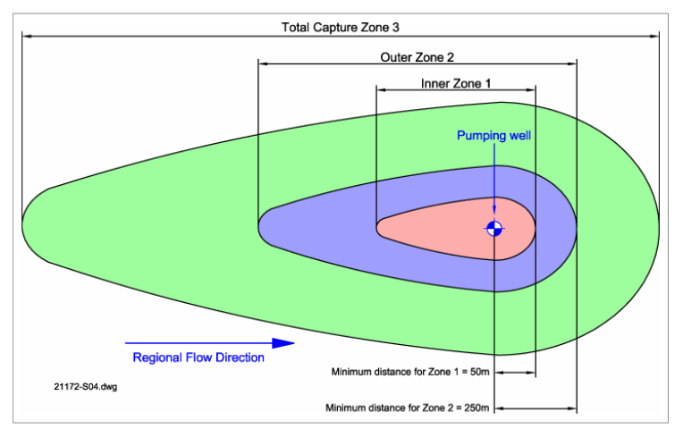
- · SPZ1 – Inner Protection Zone is defined as the 50-day travel time from any point below the water table to the source. This zone has a minimum radius of 50 meters.
- SPZ2 – Outer Protection Zone is defined by a 400-day travel time from a point below the water table. The previous methodology gave an option to define a SPZ as the area required from a minim recharge. This option is no longer available in defining the SPZs and instead, this areas must have a minimum radius of 250 or 500 meters around the source which varies according to the size of the abstraction areas.
- SPZ3 - Source Catchment Protection Zone is defined as the area around the catchment that participates in the recharge of the groundwater sheet for the catchment. For heavily exploited aquifers, this protection areas can be defined as the whole recharge area of the aquifer when the ratio of licensed abstraction to recharge is >0.75. There is still the need to define individual source protection areas to assist operators in catchment management.
- A fourth zone SPZ4 or “Zone of Special Interest” was previously defined for some sources. SPZ4 usually represented a surface water catchment which drains into the aquifer feeding the groundwater supply. In the future this zone will be incorporated into one of the other zones i.e. SPZ 1, 2 or 3.
Delineation of a protection zone is not simply a modelling approach but combines a number of steps:
- Data collation and conceptualisation
- Calculations, modelling and hydraulic capture zone production
- Technical review of hydraulic capture zones with modification, where appropriate, of the zone boundaries to produce the final SPZs
- Documentation and publication of final SPZs

Schematic representation of Inner, Outer and Source Catchment Protection Zones (from "Groundwater Source Protection Zones -Reviews of methods")
- There are also Safeguard zones (SgZs) : https://www.gov.uk/government/publications/protect-groundwater-and-prevent-groundwater-pollution/protect-groundwater-and-prevent-groundwater-pollution
- Safeguard zones (SgZs) are used for areas around abstractions where water quality is poor. A Safeguard Zone means that there will be strict enforcement of existing measures for particular pollutants and activities, and possibly new voluntary measures.
- SgZs are based on existing SPZ1 and SPZ2. SgZs are not statutory designated areas but are where additional measures are needed to improve water quality. The Environment Agency establishes SgZs under the Water Framework Directive. There are more than200 groundwater SgZs in England.
Last, we can find some “water protection zones” (WPZs). They are a statutory designation of an area where measures can be specified to deal with sources identified as being at high risk. This allows the Environment Agency, once an order is made by government:
- to apply measures in addition to other measures to manage
- to stop activities that cause or could cause further damage or pollution to water
On 14th march 2017, there were no WPZs for groundwater.
- To know where groundwater source protection zones are located in United-Kingdom, see the map on line here: http://apps.environment-agency.gov.uk/wiyby/37833.aspx
- Some recent information can be found also in the guidance of protection of groundwater and prevention of groundwater pollution, published on 14th march 2017 by The Environment Agency. https://www.gov.uk/government/publications/protect-groundwater-and-prevent-groundwater-pollution/protect-groundwater-and-prevent-groundwater-pollution
This document tells for example that there are more than 2 600 SPZs in England surrounding major abstraction sources.


